LPRCA issues 'Flood Outlook'
Article content
No one has been spotted leading animals two-by-two into a large, wooden boat.
But it doesn’t take a rocket scientist – or for that matter, a masters degree in water analysis, to be aware if 40 or so forecasted millimetres of rain materialize on top of this year’s considerable snow pack, it could lead to more than a slushy mess.
“Obviously, there is a bit of a concern for flooding,” said Long Point Region Conservation Authority Water Resources Analyst Ben Hodi Wednesday afternoon.
In response to developing conditions, the LPRCA issued a ‘Flood Outlook’ at 10:30 a.m. Thursday, intended to advise residents of the potential for minor flooding in low-lying areas.
The LPRCA takes issuing accurate statements very seriously and considers a combination of factors before doing so.
“We don’t like to cry wolf too often,” said Hodi.
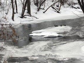
But as early as Wednesday, the LPRCA had a ‘level of concern,’ anticipating a measure of nuisance and minor flooding, particularly in flood-prone areas, as well as the potential for deteriorating ice conditions and resultant ice dam issues along the Big Otter Creek at locations including Port Burwell and Vienna.
“People should be on the alert,” said Hodi Wednesday.
Reasons for caution on predicting major flooding include the fact forecast rainfall amounts do not always translate into actual rainfall, coupled with predicted cooler overnight temperatures which should slow the rate of melting. The current forecast is being closely monitored, says Hodi, along with current and changing conditions.
The large 2013/2014 snow pack is a bit of a double-edged sword, he added. In recent years, freeze-thaw cycles have meant considerably less on the ground at once than at this or any point.
“There is definitely more snow than other years.”
Essentially stable and growing since Christmas, current estimates put its water equivalent (if all the snow was to melt at once, how much water does it represent) at between 70 and 90 millimetres. But its considerable bulk also represents an ability to absorb significant amounts of rainfall.
“We’re expecting the snow to soak up a lot of the rain.”
If the snow pack does absorb a large percentage of rainfall, it could be like putting more water equivalent into a frozen bank for a subsequent sunny day. The current 70-90 millimetre equivalent is sitting on top of a considerable amount of frozen puddles in fields, says Hodi, in place from previous thaw-freeze cycles.
“Things have really been accumulating out there on the land.”
Ideally, a large snow pack is released gradually, through warmer days and cooler nights, a measured thaw-freeze cycle.
“That’s what we really like to see,” said Hodi.
The authority will continue to keeping a close eye on the situation.
“No panicking, but definitely monitoring things very closely,” said Hodi. “We’ll issue messages and update things as need be.”
As part of the Flood Outlook, people are warned to stay away from ditches, streams, rivers and ponds as the combination of slippery banks and cold, fast-flowing water is dangerous. Ice conditions on watercourses, ponds and reservoirs are expected to deteriorate and should be considered unsafe. Parents are reminded to keep children away from these areas.
Landowners are also advised to make sure dams, culverts and catchbasins are free from debris and functioning properly.
The current Flood Outlook watershed conditions statement is in effect until 6 p.m. on Sunday. LPRCA staff will continue to monitor watershed conditions and update status as required.